
Photographing Peru – Part 2 Cuzco to Lake Titicaca
by Reinhard Thomas
January 30, 2017
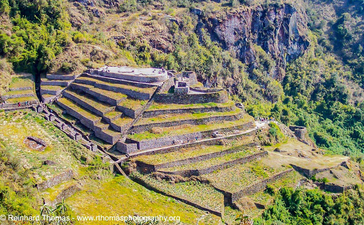
Inca ruins of Phuyupatamarca beside the trail
We are leaving the puma shaped city of Cuzco and traveling North on our way to the Sacred Valley of the Incas. We stop at Pisac to visit a traditional very colorful Native Indian market and in Ollantaytambo to admire the ruins of a temple with magnificent Inca stonework and enormous terraces.
View from the Inca Trail
The Sacred Valley once was an important area for the Incas. A large number of Inca soldiers were stationed here to protect against the Antis ethnic groups, which lived in the nearby jungle. The slopes of the steep hills in the valley have terraces, built by the Incas for agricultural use, and salt-pans which are still in use dating from ancient times, prior to the Incas.
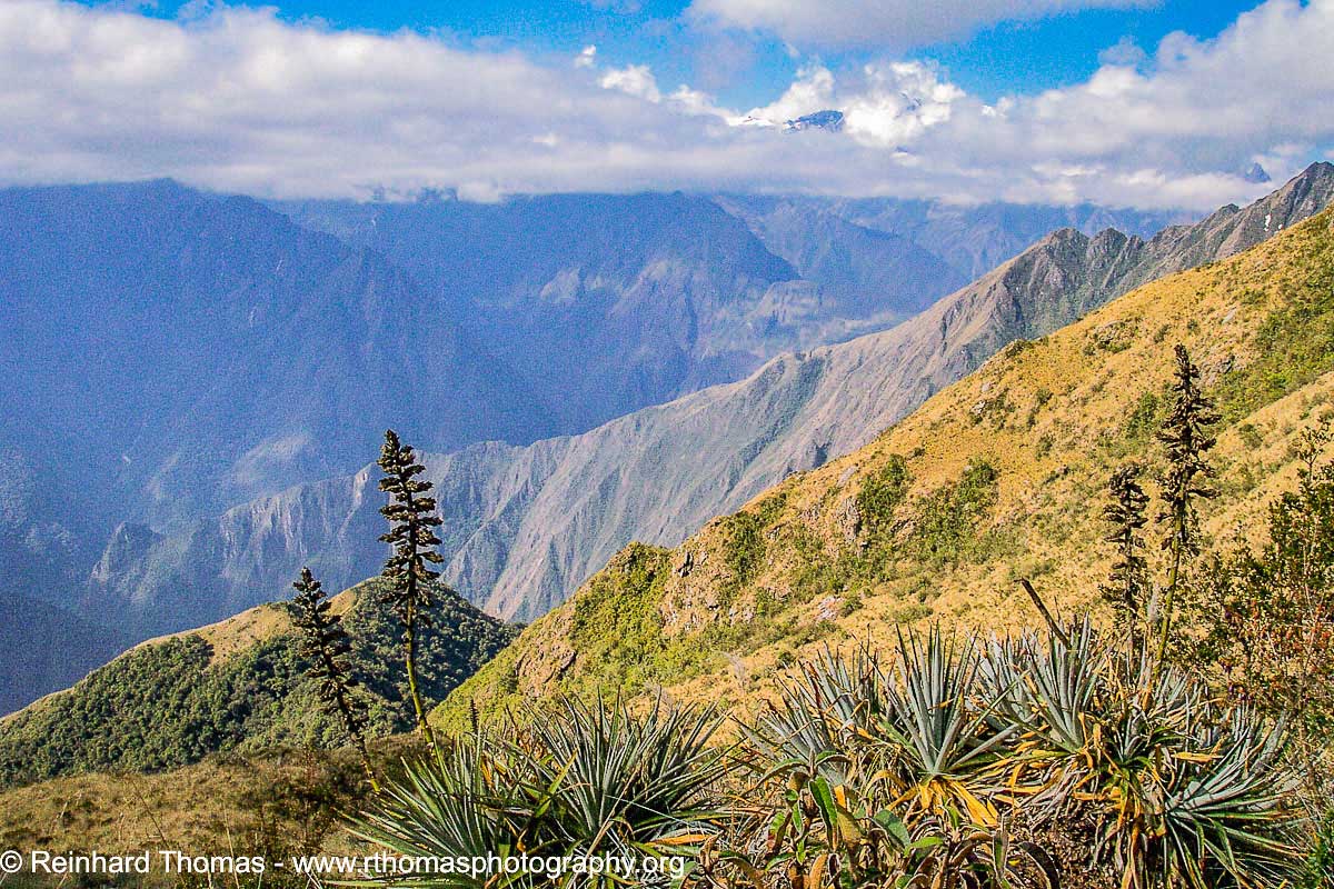
The mountains around Machu Picchu are covered in lush vegetation
The next morning we begin our hike on the classic 4 day, 45km long Inca trail. The trail is part of an ancient Inca “road system” and was only re-discovered in 1915 after the discovery of Machu Picchu by Hiram Bingham, an American archaeologist who was actually looking for the lost city of Vilcabamba but found instead, with the help of a local farmers boy, the ruins of Machu Picchu.

View into the sacred valley
For many years individual hikers walked the Inca Trail on their own but because of the garbage and damage they left behind, the Government instituted restrictions in 2003. Now a licensed guide must accompany all trekkers and the maximum number of people on the trail is 220 per day. Porters carry the stoves, tents, gas cylinders, chairs, food and some of the hiker’s personal belongings such as sleeping bags. However, the maximum load the porters are allowed to carry is 44 lbs and guards with scales at the start of the trail make sure that this limit is enforced.
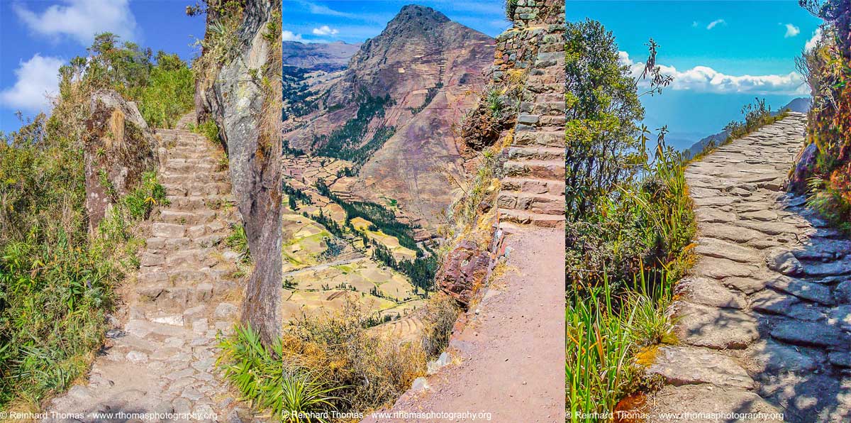
Left: steps along one of the trails, Center: hiking the Sacred Valley trail, Right: Inca trail seems to disappear into the sky.
The trail with its thousands of hand-hewn stone steps, each one a different height, crosses spectacular passes, leads through tunnels chiseled into the stone walls and offers unbelievably stunning views over mountains and through cloud forests. The trail winds its way through the beautiful Andes Mountains from the Sacred Valley to Machu Picchu.

View from the Inca Trail onto Aguas Calientes in the Valley
The first day on the trail is easy hiking, following the Urubamba River valley for most of the way. Conditions change dramatically on the 2nd day of the hike. The 2nd day is particularly demanding because you have to climb over the 4200m high “Dead Woman’s Pass”.

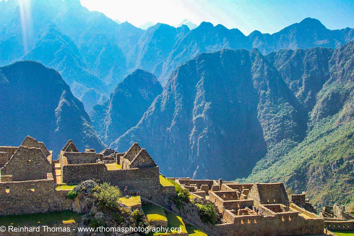
The Sanctuary of Muchu Picchu sits like a saddle on the mountain
Several Inca ruins, which were once buildings that accommodated Inca pilgrims on this ancient royal highway are scattered along the way. Lush exotic vegetation such as rare orchids, hanging moss, bromeliads and many bird species can be seen along the trail. Day 3 ends with the navigation down a stone staircase with 2,250 steps leading to the ancient Intipapa terraces and the ruins of Huinay Huayna where we spent the last night on the trail. The next morning we leave our tents at 3 am and stumble through the dark for several hours to arrive at Inti Punku, the Sun Gate in time to witness the sunrise over Machu Picchu. Unfortunately our morning started out cloudy and the sunrise was not as spectacular as it would have been on a clear day; regardless still an amazing experience.

The ruins of Phuyupatamarca from the trail
We spent a very interesting and informative day amongst the ruins of this sacred city, which was home to Inca nobility and priests. Machu Picchu is one of the most fascinating ancient sites in the world, sitting like a saddle on a mountain between forest covered mountains and steep cliffs. Almost half a million people visit this site annually.
We exit Machu Picchu on the steep mountain road to Aguas Calientes (now re-named to Machu Picchu Pueblo), the main gateway to the ruins of Machu Picchu. From there we take the train back to Cuzco.
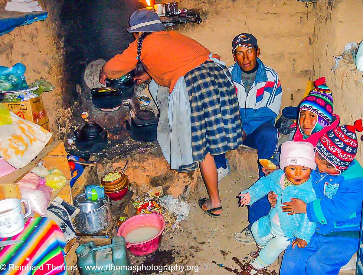
Our Quechua Indian host family on the island of Amantani prepares breakfast
The next day finds us in the bus again on our way to Puno. Along the way we see herds of vicunas, alpacas and llamas and cross the 4,321m high La Raya Pass enjoying the beautiful scenery.
![]()
Woman weaving a blanket
Puno is located on the shores of Lake Titicaca, and at 3,855 m above sea level, is the highest navigable lake in the world. Our boat brings us to the island of Amantani where we will stay overnight in the home of a native Aymara/Quechua Native Indian family. On our walk from the boat landing to our guest family’s home, we admire the beautiful snowcapped mountains on the East side of the Lake in Bolivia. I noticed light poles with streetlights along the way but knew that there is no electricity on the island; after inquiring we learned that the streetlights were installed years ago as part of an UN- help project for the developing World.

One of the many churches in Cuzco
That night the community organized a party for us in the candle-lit community hall. Local musicians played somewhat strange, repetitive sounds and the local women encouraged us to dance, which was difficult for us with this unfamiliar type of music. The social structure of the island is interesting since they have no cash system (money) on the island and everything from food to labor is traded within an island wide co-op, based on the traditional bartering system. Any supplies they need are brought in from Puno and again traded for natural goods from the island.

Lamas and Alpacca heards along the road
Amantani is not the only interesting island in the lake. Our next stop on the way back to Puno was the island of Taquile where the men of the island sit around in the center of the community, knitting woolen hats and other items of clothing while the woman work in the fields.
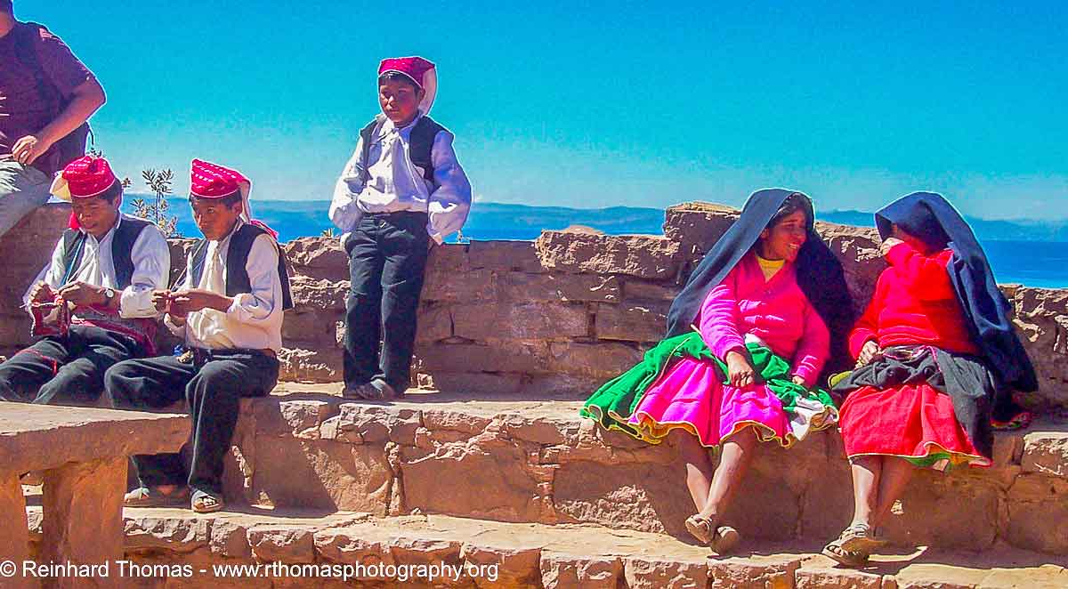
Men are knitting on the island of Taquile
This stop revealed the most interesting island on the lake. It is a large floating reed island in the bay of Puno. This island was built and is occupied by the Uros Native Indians, which demonstrated to us their way of life on the floating island. A ride in one of their artfully created reed boats was the highlight of this island’s visit.
Our motorboat brings us back to the harbor of Puno from where a rickshaw takes us to the airport to catch our flight to Quito, Ecuador, which will be our starting point for a trip to the Galapagos Islands.
Authors Biography & Contact Information

Reinhard Thomas is a photographer living in Calgary. He specializes in travel photography. Between travels he creates animal and landscape images and has a comprehensive collection of barn and grain elevator pictures.
Previous articles by Reinhard Thomas
Photographing Peru - Part I
Photographing around Devil's Island
Photographing Brazil’s Pantanal the Unknown Gem
Photographing in the Western Prairies
Photographing Madagascar
Photographing Cambodia, Kingdom of Wonder
Photographing the Spice Island of Zanzibar
Email: thomasrdu@telus.net
Web site: www.rthomasphotography.org
Phone: 403-239-3278
Click on the buttons below and share this site with your friends