text by Dr. Robert Berdan
Photos by Robert and Karl Berdan
May 8, 2011 (Updated April 2, 2012)
When I was 12 my family moved from Toronto to a small town of 10,000 - Midland, Ontario (population today is 16,300) located on an inlet of Georgian Bay. Three years later my passion for nature photography began at the age of 15. Georgian Bay is famous for its sudden and dramatic changes in weather. The east side of the Bay is dotted with tiny islands, unexpected outcrops of white pine, and fur trees. The Bay is sometimes referred to as the 6th Great Lake and is surrounded by decidous forests in the south and evergreen forests in the north. North of Midland, Georgian Bay features the 30,000 islands which in actual fact are estimated to be closer to 90,000. The rugged landscape of the area was an inspiration to the Group of Seven Painters formed in 1920. The group painted the area with a new style they felt better expressed the Canadian wilderness. I was inspired to photograph the surrounding landscape by a local professional photographer named Budd Watson (see my tribute to Budd Watson). Today parts of Georgian Bay are still untamed in spite of a growing number of cottages. The photographs in this article represent images taken over 30 years and include historical images of the Hog Bay Trestle that was dismantled in 1978 and the SS Edmund Fitzgerald that sank in lake Superior in 1975. Georgian Bay is a large area and only a few favorite areas can be shown in this short article.
Left: Sunrise over frozen ice on Midland Bay, 1972 - one of my first photographs taken with an SLR - 50 mm F1.8 lens, Olympus OM-1 with Kodachrome 64 film. Right: Aerial view of Balm Beach on Georgian Bay, Christian Island is at the top of the picture. A friend, Bruce Lauren, took me up in small plane after receiving his pilots license so I could take this picture of Balm Beach circa 1976. Kodachrome 64, OM-1, 50 mm F1.8 Lens.
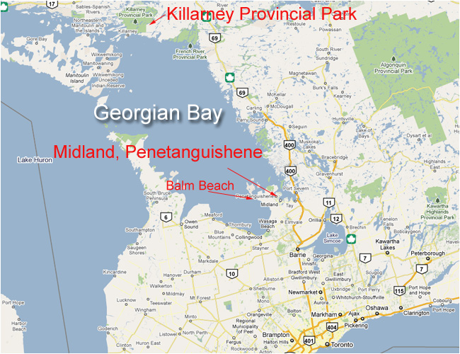
Map of Georgian Bay showing Midland, Penetanguishene, Balm Beach and Killarney Provincial Park in Ontario.
Sunrise at Killarney Provincial Park, 2009, Nikon D300 12-24 mm lens, Polarizer. The rugged terrain is part of the Canadian Shield composed largely of igneous rock and granite that in places is estimated to be almost 4 billion years old. Glaciers carved the striations and smooth surface in the granite over millions of years.
Granite with striations from the last ice age - Killarney Provincial Park. If you never tried shooting in Black and White or Sepia - give it a try if the light is flat such as on overcast days. Be on the lookout for the endangered Massasauga rattlesnake. I have never seen one, but have found lots of skins on the rocks.
SHORT HISTORY OF GEORGIAN BAY
It was said among the Ojibwa Indians that the god Kitchekewana created the Thirty thousand Islands by hurling rocks toward the shore, and the inland lakes were caused by the splash. After his labors, Kitchekewana lay down to rest on the large islands and never got up. The island today is called Giants Tomb.
White Pine Silhouette - Sunset at Go Home Bay. The area contains numerous small islands.
The French were the first to make contact with the Huron Indians in Georgian Bay back in 1610. When the British arrived in the early 1800's, Captain William Owen of the Royal Navy labeled Georgian Bay "Lake Manitoulin", but it was later renamed Georgian Bay after King George the IV. This large body of water located approximately 100 km north of Toronto is 190 km long and 80 km wide. Historically it is significant as a fur trading post and formed part of the east west passage. You can revisit Saint Marie Among the Hurons to see what life was like in the early 1600's (see photos below). In addition, in Penetanguishene they rebuilt the Military and Naval Establishment from early 1800's (Now called Discovery Harbour). I had the good fortune of working at the Naval Establishment for three summers while going to University and learned to fire a musket and Canon as part of the English 24th regiment of foot from 1824 (I am in uniform below in the left- middle middle and left-bottom pictures).
Top Left and Middle: St. Marie among the Hurons, Top right: Indian village in Midland Ontario, Middle: R. Berdan, Middle - British guard, Middle-right: Purser, Bottom Left: Loading canon at the Military Establishment. Bottom -middle: Replica of the Tecumseh boat that moored in Penetanguishene in the 1800's. Bottom right: The Martyrs' Shrine - a large Catholic church that commemorates the first Jesuits. All of these attractions offer numerous photographic opportunities. All photographs by Karl Berdan.
Historical British Naval Establishment established in early 1800 to protect Upper Canada from the Americans, located in Penetanguishene. This historic site features boats, ships stores and demonstrates what life was like in the early 1800's. I had the pleasure of working three summers as a historic interpreter at this site while going to University of Western Ontario where I majored in Biology.
Hog Bay Trestle 1972
Hog Bay is located near Port McNicoll a few kilometers east of Midland, Ontario. The Hog Bay trestle was built by the Canadian Pacific Railway and was 50 feet high and 2141 feet long making it one of the longest wooden structures on the continent. The bridge was last used in 1971 and demolished in 1978. This was one my first pictures published in the Midland Free Press Newspaper. Photograph taken with Olympus OM-1 camera, 50 mm lens, Trix-X 400 Black and white film, and a tripod.
Hog Bay Trestle
Original Photo taken on Kodachrome 64, Olympus OM-1 camera, 24 mm wide angle lens, and tripod.
Above the Emund Fitzgerald in disguise? I learned from from Ted J. Wilush at McMaster University the vessel in the photograph above is not the Edmund Fitzgerald as I thought, but in fact it is the Algoma Central Marine's V.W. Scully, (later Algosound and scrapped in 2003.) The Scully masqueraded as the Fitzgerald for a short time in late 1978/79 having been cast as the vessel to portray the Fitzgerald in a movie about the sinking. (Although the two ships looked nothing alike). The movie was never completed but footage of the Scully masquerading as the Fitzgerald has been used in many documentaries. The photograph above was taken in December of 1978. Here's as a link to the Scully's history: www.boatnerd.com/pictures/fleet/algosound.htm.
The SS Edmund Fitzgerald was an American Great Lakes freighter that made headlines after sinking in a Lake Superior storm on November 10, 1975. When launched on June 8, 1958, she was the largest boat on the Great Lakes. Here is it shown docked in Midland, Harbour circa 1973. The grain elevators have also been demolished now to make room for a marina and waterfront housing. Gordon Lightfoot, a Canadian musician who lives in the area, wrote a song about the sinking of the Edmund Fitzgerald. Watch Youtube video at the bottom of the page. See links below for more information about Great lakes ships courtsey of Ted Wilush.
Forest near Midland Ontario in Spring with Trilliums the provincial flower (May 10, 2011)
Modern Day Boat Cruises into the 30,000 Islands are available aboard the Miss Midland and from the Georgian Queen in Penetanguishene. Picture taken from Midland Point with a 70-200 mm F2.8 lens, 2010.
Go Home Bay - scenes like this inspired the Group of Seven Painters and continue to inspire modern day photographers.
BREBEUF LIGHTHOUSE
Georgian Bay contains 32 lighthouses which make spectacular subjects for photography. The trick is that some of them are
only accessible by private boat and if you want to get dramatic light you will have to be on location at sunrise or sunset.
Brebeuf Island is just west of Georgian Bay Islands National Park and is only accessible by boat. The island was named after Father Brebeuf a French Jesuit priest who worked with the Huron Indians at St. Marie among the Hurons. The Lighthouse was built in 1878 on Gin Rock Island and then moved to Brebeuf Island in 1900. The tower is 35 feet tall. The picture above was also featured as a full page advertisement for Canadian tourism in Canadian Geographic Magazine. My father and I travelled by boat and waited 4 hours for the sun to set on the lighthouse before we had to scurry back home. I used a wide angle lens (20-35 mm), polarizer and a tripod and recorded the image on Fuji Velvia film.
Left: Western Islands Lighthouse located 43 km south west of Parry Sound, built in 1895 and accessible only by private boat . Right: Cove Island Lighthouse first lit in 1858 located on the north east corner of Cove Island near the entrance of Georgian Bay from Lake Huron. You can view this lighthouse if you take the MS Chi-Cheemaun Ferry from the Bruce Peninsula to Manitoulin Island.
BALM BEACH
Balm Beach 1972. The north east side of Georgian Bay contains the Canadian Shield, but the south east part of the bay contains miles of white sand beaches that extends to Wasaga Beach and part way to Owen Sound. The white sand was deposited by glaciers that washed up on the shore of Nottawasaga Bay. The water is clear and cold and the sandy bottom can be seen even at depths of 50 feet or more. Photographed with an Olympus OM-1 camera, 50 mm lens, F16 on a tripod using Kodachrom 64 film.
Sunset on Balm Beach - 2006. I used a 2 -Fstop hard edge neutral density grad filter to darken the sky around the sun.
Colourful Sumac leaves surround a marsh in the Port Severn region, October 2009,
Nikon D300, 17-55 mm lens, polarizer and tripod.
Bone Island in Autumn. This island is one of many small islands on Georgian Bay that are a favorite mooring place
for boats on weekends during the summer. Photographed on Kodachrome 64 film.
Owl Irruption. In winter this Great Gray Owl along with many others migrated into fields around Midland to search for food.
February 14, 2005.
Sunset Port Severn Ontario. This is my brother Frank's backyard. The Bay is a protected area for fish spawning. (No filters,
Nikon D300, 17-55 mm lens, Tripod, F22).
WYE MARSH WILDLIFE CENTRE
Boardwalk in the Wye Marsh Wildlife Centre in Midland Ontario
Lilly Pads in the Wye Marsh
The Wye Marsh is located just behind St. Marie Among the Hurons on the outskirts of Midland, Ontario and is a great place to visit for anyone interested in wildlife. Birds, insects, frogs and many other aquatic organisms can be seen. There are dipping nets where kids can examine some of the life that lives in the water. The Center also hosts guided canoe trips and a Trumpeter Swan program. Another common sight are painted turtles which often crawl up on floating logs to sun themselves. Beaver, herons, red-winged blackbirds and many other species can be photographed.
Wye Marsh from board walk, you will see painted turtles and leopard frogs on water lilies and floating logs.
In winter the Georgian Bay area is a mecca for snowmobilers and cross country skiing. In Summer the area attracts boaters, swimmers and fishermen. For the most part the area is known as cottage country and its one of the reasons I enjoyed living and growing up in this region. Autumn is in my opinion the best time for photographers (see article Autumn in Ontario Photography). Almost any camera will do, but for those that take photography serious a Single lens reflex camera with a wide angle zoom lens are recommended. Attach a polarizer to the lens for the most saturated colour and to reduce reflections off the water. A tripod will help you compose more carefully and take sharper pictures. For sunset and sunrise add a graduated neutral density filter (see article on these filters here) and you will be able to capture more dramatic pictures.
Female, American Goldfinch - Port Severn. Nikon D300 camera with 300 mm F2.8 lens.
American Mink - photographed in Port Severn while enjoying a BBQ at my brothers home - I was able to get this photo
because my camera was with me and ready.
Monument Channel at Sunset
The Georgian Bay area is a paradise for recreation and photography, what you photograph will depend on your interests and how much time you have, but always keep your camera close by and you will see more then the average person. The best seasons for photography are Summer and Autumn though you can get good pictures in any season. Also be sure to check out some of the historic attractions and boat cruises. For more information about the Georgian Bay area check out some of the links below. RB