
MV Uchuck III from Gold River
Each Autumn I try to visit some new and remote area of Canada in order to take photographs. This was my third trip to Vancouver Island. In September of 2004, I drove from Calgary to Vancouver Island with my father who also shares my passion for photography. After taking the Ferry from Horseshoe Bay to Nanaimo, we drove north to Campbell river and then west to a small town called Goldriver where we stayed overnight. The next morning we drove to the Gold River dock to meet the Uchuck III, a 136-foot passenger and freight vessel providing service to Nootka, Esperanza and Kyuquot Sounds. The boat trip to Nootka Island was a pleasant 6 hour cruise. The boat stopped at logging camps and commercial fish farms along the way to drop off supplies. The highlight of the trip was to get a glimpse of Luna the Killer whale. Luna was gaining some fame as he would often approach boats and the Natives believed he was a reincarnated chief. The channel cruise was scenic, but evidence of clear cutting was everywhere and most of the forest was second growth and this saddened me. Vancouver Island has some of the most beautiful landscapes I have ever seen, especially where they have preserved some old growth trees. Unfortunately most of the old growth forests are disappearing due to logging and only a few pockets are being preserved.

Luna the Killer Whale leading the Uchuck III on our trip to Friendly Cove
Luna was a Killer whale born in Puget Sound, but became separated from his mother and spent five years living in the Nootka Sound area where he developed a strong attraction to boats and people in the area. The Mowachat/Muchalaht First Nations believed Luna was a reincarnation of a former chief. Luna was subsequently killed by a tugboat in 2006. In 2007, CTV produced a made-for-television film, Luna: Spirit of the Whale and The documentary, Saving Luna played in theatres across Canada in 2009 (Wikipeadia).

Nootka Island is off the West Coast of Vancouver Island. To get there you either take the Uchuck III or a Seaplane from Gold River, BC. We took the Uchuck III which dropped us off at a logging camp on the south end of Nootka Island and our hosts drove us to their cabin on Beano Beach where we stayed and photographed for several days.
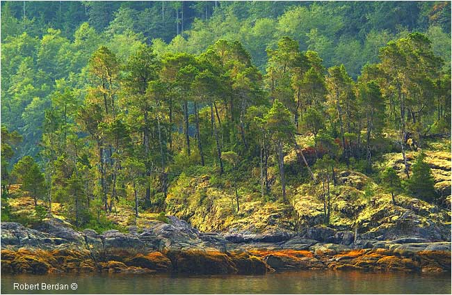
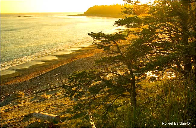
Coast line along route to Friendly Cove - most of the area has been forested. A few trees - ancient trees that were used by natives (culturally modified) have been left standing. The area is popular for kayaking and fishing.
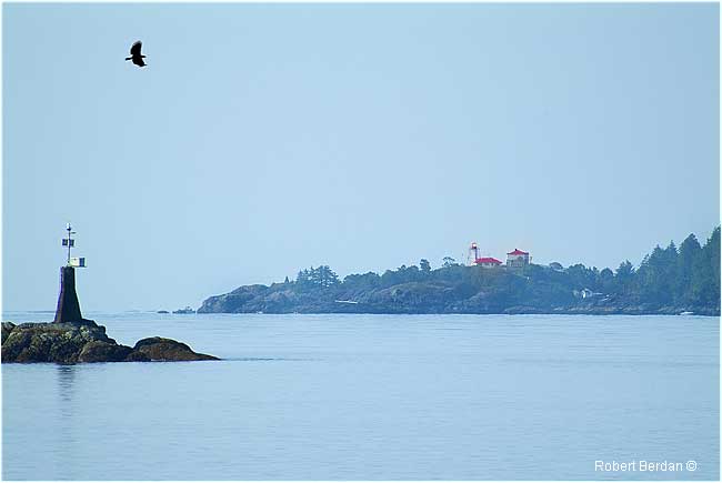
Friendly Cove lighthouse from the Uchuck III
The Uchuck dropped us off at a logging camp in Plumper harbour on Nootka Island. We were picked up by our hosts Pat and Jan who drove us over some logging roads to their Bed & Breakfast cabin located on Beano Beach. Their cabin is located on the Nootka trail, a 35 km trail that starts at the North end of the Island and extends 35 km south to Yuquot also called Friendly Cove. Hikers who plan to walk the Nootka trail are flown into Louie Bay and most hikers take about a week to walk to Friendly Cove where they take the Uchuck back to Gold river. The trail is recommended for experienced hikers and should never be attempted alone as even the most experienced hiker can slip and break a leg.
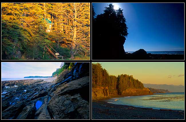
Top Left: View of cabin where we stayed on Beano Beach. Top right: sun behind trees south end of Beano Beach. Bottom left: Beano Beach looking north. Bottom right: Beano Beach around sunset looking south.

Campers along the Nootka Trail at the North end of Beano Beach. The Beach is covered in pebbles.

Photographer setting up tripod at Low Tide on Beano Beach

High Tide on Beano Beach
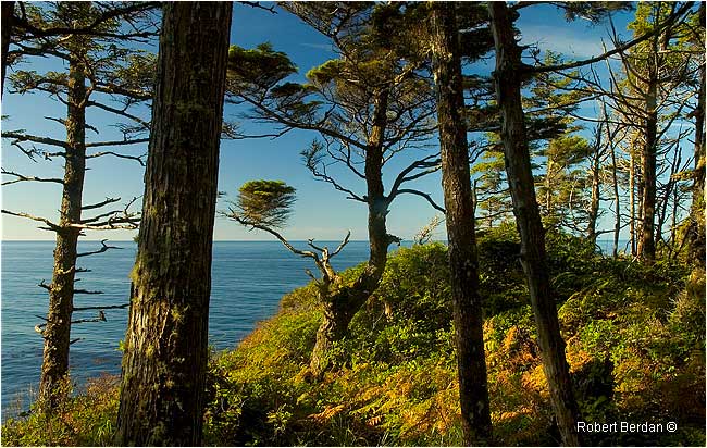
View of the Pacific Ocean from the Nootka Trail

My father standing in the forest along the Nootka Trail.
Beano Beach at sunset - view from Cabin walkway down to the Beach
The land on Nootka Island is not protected being mostly private or crown land under the jurisdiction of BC Ministry of Forests. Most of the trail extends along beaches with sections requiring some bushwhacking through the thick undergrowth. We choose to use a cabin as our base and hike up and down the trails during the day to take photographs. This allowed me to take more camera equipment then the average hiker can carry. There were only a couple of cabins on the beach and even the bed and breakfast where we stayed is no longer in business as one of the owners had some health issues. Most of the land on Nootka Island is private or belongs to natives and the zone of protected land is only 200 meters. There is no cell phone service or electrical power. Everything has to be shipped or flown in. The trails are not patrolled though while we were they we usually saw at least one party of hikers pass by each day.
Photographs of the life we encountered along the Nootka Coast and Trail

Tide pools were filled with Anemones and starfish (Pink-tipped Anemone, Giant Green Surf Anemone, Purple Star and Blood Star). Salal berries and bushes fill in the forest floor making it difficult to walk in places. Banana slugs were common along the trail in the rainforest. Western Sandpipers were common along the Beach. Barnacles and clams covered some of the rocks at low tide.

Left: South end of Beano Beach - there is a rope to assist hikers climb up the steep slope. Right: Beano Beach at sunset.

View of Beano Beach from Cabin at sunset.
At night my father and I would sit outside on clear nights and marvel at the milky way which we could see all the way down to the ocean – the only artificial light we could see belonged to a buoy out in the Pacific. Black bears and wolves are common on the island and we saw lots of berry-filled scat and wolf tracks on the beach in the morning. We also saw whales passing by offshore, a few sea otters and a variety of birds along the beach. In the tide pools we photographed Anemones, star fish, and snails. During the day we would hike and explore the Nootka trail and our hosts showed us a few of the large Cedar trees that have not been cut down because they were culturally modified which simply means the First Nations people used them in the past in order to make a variety of products. To learn more about Culturally modified Cedars read this report by the David Suzuki Foundation.
From a photographers Point of view what to bring if you plan to photograph the Nootka trail
The main issue is how much weight you can packback and still have room for food, clothing and shelter. Ideally I would bring one DSLR camera, 18-200 mm lens, several battery packs, a lightweight tripod, a second compact waterproof digital camera with HD video (e.g. Pentax OPTIO) for photographing in tide pools. If you can afford a Sherpa - even better.

View of Beano Beach from the north end looking south at sunset.
In places the Nootka trail is clear and easy to follow and in other places covered in bush and requires that hikers traverse some creeks. Anyone hiking the trail needs to be aware of the tides as the beach often disappears in high tide in which case hikers have to do some bushwhacking. We talked with some of the hikers along the trail including some from Calgary. The trail is popular in the summer, but not near as busy as the West Coast Trail. There are a few websites that show and describe the trail (see links below) and I found a useful booklet “The Nootka Trail – a Backpackers’ Guide 2nd Edition” by Pal Horvath that describes the trail in detail including pictures from along the way. The Nootka trail offers a wilderness adventure for those seeking to get off the beaten path. If our government was smart they would protect this area and extend the protection from the coast to at least a 1000 meters inland so future generations might be able to experience its' beauty. RB
Links to Additional Resources
Publications
Pal Horvath (2004) The Nootka Trail - A Backpackers' Guide 2nd Edition. ISBN 0-919537-57-X.
Heather Harbord (1996) Nootka Sound and the Surrounding Waters of Maquinna. Heritage House.
ISBN 1-895811-03-1
John R. Jewitt's Narrative - White Slaves of Maquinna (First Edition 2000) Heritage House Publishing. Describes the capture and slavery of R. Jewitt at the hands of the Maquinna and was first published in 1815. It describes the early life of the First Nations and history of Friendly Cove. If you plan to hike the Nootka Trail, this paper back would be a great companion as you travel along the trail and uncover its history. ISBN 1-894384-02-4.
[ Top ]
|
