Canadian Prairie Photography Expeditionby Robert Berdan
Canola Field, East of Calgary, AB
Photographing the prairies is challenging and if you have heard different it’s BS. Good prairie photographs must be earned a few at a time. The sky is the most dominant feature in the prairie and the land extends out to the horizon in all directions. There is the odd barn, silo or tree that breaks up the skyline and monotonous is the word most folks that drive across the prairies use to describe it. Roads lead to their vanishing point and the prairies makes me feel small. Everything seems far apart – especially gas stations when you drive the back roads. I get a similar feeling when I look up at the night sky. In parts of the prairies there are coulees, marshes, hills, rivers and badlands that break up the landscape. These areas are my favorite photographic locations as the light creates shadows in the morning and evening that adds texture and depth to the landscape. Animal life, especially birds seem to be concentrated around water and in marshes. The wind is also a constant companion on summer afternoons as it forms waves in the tall grass and wheat fields. The prairies are also characterized by abandoned buildings in various states of decay and they are a reminder that life can be hard and unforgiving and not everyone that tries to make a living here succeeds. It takes time to become tuned into to a place and I believe I am just beginning to see possibilities on the prairies.
Moon rise over the prairies near Maple Creek, Saskatchewan I am trying to capture the beauty of the Canadian prairies and some of its’ unique animals and plants. I will include separate articles on the badlands of Alberta in the near future, this article features some of my favorite images taken on one weekend July 24-25 where with my friend Halle Flygare we covered about a 1400 km loop from Calgary. That’s a lot of ground to cover in one weekend, but when the day starts at 4:00 am and goes to about 10 pm it’s possible see and photograph a lot in a relatively short period of time. I am just beginning to appreciate the subtle beauty of the prairies, it’s there, I could even see it staring into the gold and black eyes of a prairie rattlesnake.
Prairie Rattlesnake photographed at Red Rock Coulee - used a 300 mm F4 lens and then a 100 mm Macro lens. The rattle snake is resting on Bentonite - mixture of clay and volcanic ash. The snake never struck out at us or acted aggressively.
Prairie Weekend Expedition - July 24-25Our Route - See Zoomable map at the bottom of the page Halle Flygare and I left my place in Calgary at 4:45 am on Saturday to start our 1400 km journey through the prairie. Halle’s wife Linda drove him from Canmore leaving about 3:45 am to get him here in time to leave. You have to be a keener to get up that early on a Saturday morning to take photographs, but the rewards are beautiful sweet light and the forecast was for two or three hot sunny clear days. We grabbed breakfast at McDonalds at 5:00 am and headed north of the city. My plan was to head east to Brooks and then north to Patricia and Jenner where I hoped we might find some rattle snakes along the highway on a tip from my friend Dr. Wayne Lynch. From Jenner we headed to Empress where we ate lunch at the only restaurant in town. We drove to Saskatchewan along some back roads, and then took a ferry across the South Saskatchewan river and drove to Leader, Saskatechewan before heading south on highway 21 to Maple Creek where we stayed overnight.
Road to Fort Walsh from Maple Creek was surrounded by small hills, numerous white-tail deer, pronghorn antelope, meadowlarks and hawks. On Saturday evening we drove down highway 271 toward Fort Walsh, this was a very scenic drive for landscapes and teeming with wildlife. Next morning we were on the road by 4:30 am heading south on highway 21 toward the far west corner of Saskatchewan. We enjoyed a full moon and it was still dark for the first hour on the road. I drove cautiously because there were deer crossing the road and all I could see was my headlights reflecting off their eyes.
White-tailed deer and fawns Near the town of Eastend we drove through the Frenchman river valley, which was beautiful in the early morning light. We rounded the bottom corner of Saskatchewan and headed back to Alberta on a dirt road ( 501) passing numerous hawks sitting on fence posts and photographed many herds of pronghorn. We could see the Sweet grass hills in Montana along much of the route through southern Alberta. We only passed one other vehicle so this is not a place you want to have a car problem or to be looking for a gas station – go with a full tank. In some places there were no fences in sight and we could imagine that this might be what the prairies looked like before it was settled.
Canola Fields south of Leader Saskatchewan Finally we headed north on paved highway 889 to Manyberries, but the town was still sleeping when we arrived around 9:00 am. We didn’t see a single person and all we wanted was to buy a cup of coffee. We made our way north to Red Rock coulee on highway 887. Red Rock Coulee is about 20 Km south of Seven Parsons where the road does an S shaped bend. Red Rock Coulee is a natural area and is not marked on most road maps. There is however a sign on the highway that now points out this natural area. Just before turning into Red Rock coulee we stopped at an old haunted church building whose walls are starting to cave in. Behind the church was a small graveyard with about a dozen small white crosses marking the graves. I don’t normally photograph graves, but something drew me over. As I bent down to take a photograph I could feel something tugging at my legs, was it the dead reaching for me? Ok I am exaggerating, but the graves did make me think about those haunted movies and there was an erry sound of flies buzzing.
Abandoned Church near Red Rock Coulee, AB
Graves behind abandoned church near Red Rock Coulee, AB We headed over to Red Rock coulee and hiked down to the first section of boulders. It was around 10 am and it was just starting to get hot. On the main path into the coulee, Halle noticed a rattlesnake that I must have walked right by. After photographing the rattlesnake and many of the rocks we drove to Medicine hat for breakfast then headed back to Calgary stopping to photograph bright yellow canola fields and visiting some sloughs looking for birds. In all we covered about 1400 km, I slept only a few hours that weekend.. There is a lot more territory I want to explore in Saskatchewan this summer starting with the Sandhills near Blumenfeldand then Grasslands National Park. While everyone in Calgary heads to the Mountains I will head the other direction over the summer and see if I can't discover what makes the prairies special.
Pronghorn Buck photographed in Southern Saskatchewan 300 mm F2.8 lens & 1.5X tele-extender Nikon D300
Swainson's Hawk at sunset, near Maple Creek, Saskatchewan
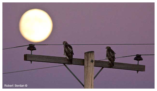
Hawks on telephone pole with full moon behind near Maple Creek, Saskatchewan
Annual Sunflower along the road side Some tips for traveling through the prairies to take photographs are:
Common Snipe, AB
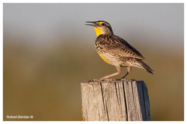
Western Meadowlark near Maple Creek, Saskatchewan
Slow down and save our rattlesnakes - Sign near Jenner, AB
Prairie Rattlesnake, Red Rock Coulee, AB Zoomable Map
Zoom and Drag to see our Driving Route for the Prairie Expedition - Map also shows location of Red Rock Coulee
[ Top ] |